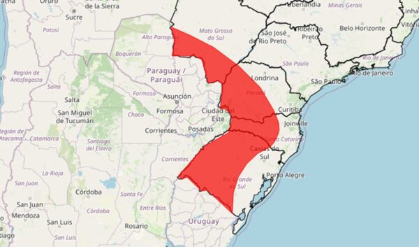
A Red Storm Warning will be in effect for four states starting this Sunday (11/16). According to the National Meteorological Institute (Inmet), heavy rain is expected to hit the western Rio Grande do Sul, Paraná, Santa Catarina, and southern Mato Grosso do Sul states from Sunday to Monday (11/17).
Please also read
-
Brazil
Inmet issues storm and hail warnings for eight states
-
sao paulo
Inmet issues orange and yellow warnings for storms in SP state
-
Brazil
Inmet maintains orange warning for 7 states after tornado in Parana state
-
Brazil
InMet issues orange storm warning for seven states after tornado outbreak
Forecasts call for rainfall to exceed 60 mm per hour or 100 mm per day in these areas. Winds exceeding 100km/h and hail are also expected.
emergency alert
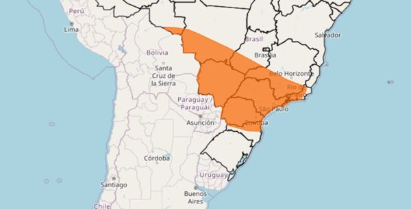
An orange storm warning is in effect for the central and southern regions of the country. In São Paulo, Rio de Janeiro, southern Minas Gerais, Goiás and Mato Grosso, precipitation is expected to range from 30 to 60 mm/h, with winds ranging from 60 km/h to 100 km/h.
 orange alert
The strong storm is the result of a new cold front that is expected to move through Rio Grande do Sul and into the Midwest and Southeast states.
This rapid movement is forecast to bring showers throughout Sunday (16th) and Monday (17th), with the possibility of rain becoming heavier in some cases, producing thunderstorms, hail and strong winds exceeding 100km/h.
This system continues into the Southeast and Midwest on Monday (11/17). In the morning, the risk focus is on the states of Paraná, Mato Grosso do Sul and São Paulo.
The unstable situation spread in the afternoon, affecting areas of Minas Gerais, Mato Grosso and Goias, and is expected to reach Rio de Janeiro by night. Temperatures are expected to drop significantly after the front passes, with frost expected to form in the south on Tuesday (11/18).